Versie door Kamonu(overleg | bijdragen) op 16 apr 2025 om 15:16 (Nieuwe pagina aangemaakt met '<br> * 45px When working with a point place the place is shown enlarged white blue outlined. Here a selected place of the garage category. * 135xpx A selected area place is shown as a turquoise polygon with the black move handle. * 135xpx Area places are shown as a pink polygon. <br>')
This page lists the symbols, colors, and other items displayed in the Waze Map Editor and provides a reference for further explanation.
In addition to the map as it is displayed by default in the Waze Map Editor, scripts can customize the map and add color and other symbols. This page only includes the standard map components.
Roads
Enable the map layerRoad to show and maintain. Multiple selections possible.
A place of the logies category with subcategories such as hotel, camping, cottage, bed and breakfast
A place of the buiten category with subcategories such as park, playground
A place of the natuur category with subcategories such as river, canal, sea, lake, forest, trees
A parking lot is always an area place. Enable the map layer to display and maintain it.
A place of the woning category is always a point place and has a subcategory eigen woning. Enable the map layer to show and maintain it.
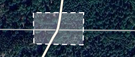
When working with a point place the place is shown enlarged white blue outlined. Here a selected place of the garage category.
A selected area place is shown as a turquoise polygon with the black move handle.
Area places are shown as a pink polygon.
Kaartopmerking
Een kaart opmerking. Opmerkingen kunnen op de kaart gezet worden als punt-opmerking en als gebied-opmerking. Beiden zijn wit. Schakel voor dit beeld de kaartlaagKaartopmerkingen in.
Afsluitingen
Voor het vertonen en onderhouden van Closures moet de kaartlaagAfsluitingen geactiveerd zijn:
 see Freeway
 see Major Highway
 see Minor Highway
 see Ramp
 see Primary Street
 see Street
 see Narrow street
 see Off-road
 see Parking Lot Road
 see Private road; destination traffic
 see Ferry
 see Railroad
 see Runway/Taxiway
 see Walking trail path with destinations
 see Pedestrian Boardwalk, path without destinations
 see Stairs
 The red outer lines indicate that the street name is missing
 The brown broken line indicates that the road is unpaved
 The arrows indicate a 1-way traffic road in the direction indicated by the arrows
 The red crosses indicate that the direction of travel is unknown
 The Yellow breaks indicate a restriction. Here on a regular Street
 The blue line indicates a toll. Here on a Freeway
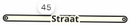 The number
  next to the road is a house number
 A new segment
 An existing selected segment
 A segment to be deleted
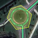 A Junction Box
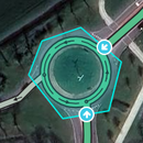 A selected Junction Box with the inputs


 and
and  see Junction Arrows
 see Soft turn and on the USA wiki
 and
and  see U-turn
 en
en  see Speed cameras
 see Railroad crossing
 see Tol
 A place of the garage category with subcategories such as Gas Station and Laadstation
 A place of the vervoer category with subcategories such as Bridges, Tunnel and Verzorgingsplaats
 A place of the professional en openbaar category
 A place of the winkels en diensten category
 A place of the eten en drinken category
 A place of the cultuur en drinken category
 A place of the overige category with subcategories Bouwplaats to use for new residential areas
 A place of the logies category with subcategories such as hotel, camping, cottage, bed and breakfast
 A place of the buiten category with subcategories such as park, playground
 A place of the natuur category with subcategories such as river, canal, sea, lake, forest, trees
 A place of the woning category is always a point place and has a subcategory eigen woning. Enable the map layer to show and maintain it.
 When working with a point place the place is shown enlarged white blue outlined. Here a selected place of the garage category.
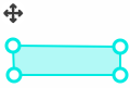 A selected area place is shown as a turquoise polygon with the black move handle.
 Area places are shown as a pink polygon.
 Een kaart opmerking. Opmerkingen kunnen op de kaart gezet worden als punt-opmerking en als gebied-opmerking. Beiden zijn wit. Schakel voor dit beeld de kaartlaag Kaartopmerkingen in.
 Een nog niet actieve afsluiting, zie Closures
 Actieve afsluiting, zie Closures
 Een niet meer actieve afsluiting, zie Closures


 Nieuwe UR's update requests van nul tot vijf dagen open zijn geel; een zonder en een met reactie
 Oranje UR's staan tussen de 6 en 14 dagen open.
 Rode UR's staan 15 dagen of langer open.
 Afgesloten UR's. Grijs geeft aan probleem niet geïdentificeerd, groen probleem opgelost
 Dit symbool staat voor meerdere UR's. Zoom in voor de afzonderlijke UR's.
 PUR, place update request. Het getal geeft aan dat op deze locatie er drie Plaats aanpassingverzoeken staan.
 Een Flagged place update request
 Een probleem op de kaart, zie Kaartproblemen
 Een suggestie voor een kaartwijziging van een editor met een te laag om de aanpassing zelf te maken.
 Het segment voorstel heeft betrekking op het lila segment.


