Restart the WME at a specific location: create a PL of the location and bookmark it.
To easily move and remove geometry nodes near an intersection: select both segments.
Split a segment into two segments: add a new road and connect it to the segment to be split at the location where you want to split the segment, then remove the newly created road again.
Force a sharp corner with a micro dogleg (mDL): By drawing a segment with a kink in the last meter, a sharp corner can be forced with a connected segment, which forces or prevents certain processing. In the app, the segment appears to connect straight and perpendicular to the connected segment; only when zooming in the kink is visible.
New road, not yet available for traffic
If you want to map a new road while it is not yet available for traffic, follow the next steps:
Initial:
- Draw the new road segments.
- Add Restrictions that effectively close the affected segments to all traffic.
- Connect the segments to the rest of the road network.
Wait for the Map update that publishes the new segments.
- Remove the restrictions.
- Add Closures to close the road segments.
When the road segments are opened to traffic:
- Remove the Closures.
Select multiple Segments: Hold down the Ctrl key and click on the segments to select.
With A you can toggle between making the Junction Arrows transparent and back to the normal display.
Skip a suggested street or place name with the Esc key.
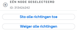
With the shortcut commands QW - where Q stands for Turns in all directions denied and W stands for Turns in all directions allowed - or via the WME buttons (see picture), all intersection arrows will be set to green. But, beware: this also removes the Lane Guidance from the intersection. So, don't use it!
Check roads on the satellite image: Temporarily disable the Roads map layer. To toggle the Roads map layer on and off, use the key combinationShift-r.
Use Alt-shift-r to refresh (reload all WME layers) without reloading the entire browser window (F5).
Use Ctrl- and Ctrl+ to zoom in and out of the map.
Use Shift-Z to toggle between showing all disallowed connections on the screen and back to normal display.