Closures/en: verschil tussen versies
wazeopedia>Kamonu Geen bewerkingssamenvatting |
k 1 versie geïmporteerd |
(geen verschil)
| |
Versie van 22 feb 2025 10:34
Closures
- Where is the best place to enter closures? In the WME or via Wegstatus? See Closure procedures.
Real-time Closures
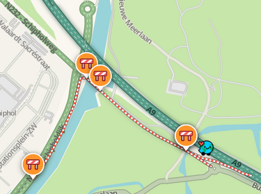
Real Time Closures (RTC) are used when a road or turn is temporary is closed. Placed closures are immediately active. From the moment a closure is active, routes are no longer provided over the closed segments. Active closures are indicated in the app and on the Live map with candy stripes (red-white stripes) on the closed segments.
A closed segment is treated as PB by Waze. This means that you will be brought closest to your destination as the crow flies. So keep that in mind when closing longer segments; where is the user directed?
In addition to closing one or more segments, specific turns ![]() can also be closed. For an explanation of this type of closure, see the Turn Closures page.
can also be closed. For an explanation of this type of closure, see the Turn Closures page.
Closures can be entered - when the Closures map layer is activated - by editors with Level 3 and higher and by members of the Closure team.
App closures

App users can indicate a road closure in the app when they encounter them during their ride. The notifications are immediately active as an hour-long RTC and automatically shared, via the closures bot with the editors in the Slack channel: .com/archives/C05N7S3PF1U #closures-bot.
The date on which an App closure is entered is used as the start date of the closure. App closures are almost always 1-way traffic closures.
To change the end date of an App closure: remove the App closure and add a new one.
Closure information
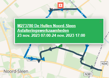
An important source of road closures is the Melvin website. Melvin is used by road authorities to report work and events.
Other sources are:
- The Bouwapp and apps from specific road construction companies / project developers.
- Andes, an accessibility portal is available for various cities, for example The Hague
- Municipality websites
- Local media
Closure requests
Requests for closures are welcome in the Slack closure channel. Wazers who want to report closures and do not have a Slack account can do so via the forum: Dutch forum closures.

Specify your closure request as follows:
- Level
- City and optional street name.
- Start date and time / End date and time
- Reason for closure / description
- A permalink of the segment to be closed
- Source of the closure information
Enter Closings
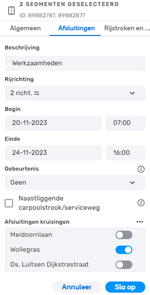
Select the segments for which you want to enter the closure and click on the Closure tab.
Now click on the Add a new closure button.
Then enter the following information:
- Description: If possible, provide a description of the work and the source. For example, "Asphalting work - Melvin 257413", "Work - Municipal site" or "Closure - own observation". If the Description field does not have enough space, add a Map Comment.
- Direction: A→B, B→A, 2 dir.⇆
- Start and End date and time of the closure.
- Event: None or one of the available Major Traffic Events.
- Adjacent carpool lane / service road: When a certain amount of traffic drives over a segment with an active closure, this closure can be lifted. This is checked every 10 minutes. When there is no more traffic, a lifted closure will return until the end time is reached. This feature can be turned off by checking Adjacent carpool lane / service road.
- Closed intersections: Indicate which intersections are closed to cross traffic.
And then click on the Save button.
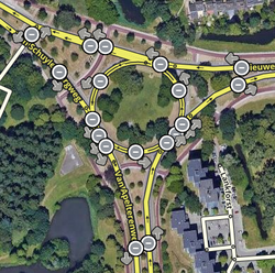
 The closure is shown with black arrows indicating the closed directions. Here, both directions are closed. The closure of one direction is indicated with one black arrow in the closed direction.
Comments
- Closures of highway entrances and exits must be placed manually, preferably via Wegstatus. Short-term entrance and exit closures, such as pruning and felling work and the cleaning of gullies and wells, are not processed in Wegstatus.
- Closures entered from the editor are recorded in the segment history. The date and editor will then show "Road Closure added".
- Be careful with relatively short-term closures: Do not close roads for closures that are expected to last less than the detour via the entire alternative route. Consider, for example, closures of the Houtribdijk, Afsluitdijk, Zeeland Bridge, Westerscheldetunnel.
Closure status
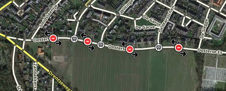
Closures are shown in four stages in the WME:
- future closures (grey sign)
- active closures (red sign)
- suspended closures (orange sign)
- past closures (white board)
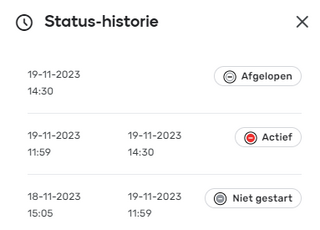

You can request the Status history by clicking on the status tag.
past closures remain available for seven days.
A closure is suspended when the closure time has started, but there is still real-time traffic on the segment.
Scripts
The script WME Closure Details can be used to display Closure details, also for closures outside your editable area. The script WME Advanced Closures is useful for periodic and imported closures.
And further
- CCP partner Wegstatus collects closure information from various Dutch organizations. This information is used for scheduled and real-time closures in Waze.
- In some areas, Security Regions manage RTCs.
- If a termination is created based on partner data, the provider is indicated in WME.
- See also Update requests on Freeways
- For more information about closures, see the global Real time closures page.
