Waze Map Editor/en: verschil tussen versies
Geen bewerkingssamenvatting |
Geen bewerkingssamenvatting |
||
| Regel 45: | Regel 45: | ||
[[File:NL-WME-Weg.png|80xpx|Road]] A [[Road types|road]] can be added via this option. | [[File:NL-WME-Weg.png|80xpx|Road]] A [[Road types|road]] can be added via this option. | ||
[[File:NL-WME- | [[File:NL-WME-Gebied.png|95xpx|Area]] This option provides support for working with [[Area|areas]]. | ||
[[File:NL-WME-Hazards.png|95xpx|Hazards]] This option allows [[Hazards|Hazards]] such as speed cameras, railway crossings, toll gates to be maintained. | [[File:NL-WME-Hazards.png|95xpx|Hazards]] This option allows [[Hazards|Hazards]] such as speed cameras, railway crossings, toll gates to be maintained. | ||
Versie van 30 mrt 2025 13:09
Waze map editor
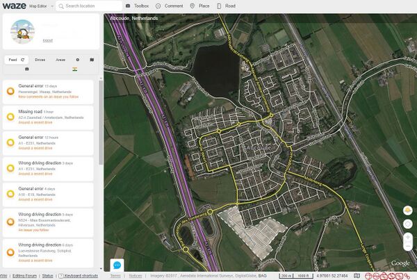
With the Waze Map Editor (WME) the Waze maps are maintained.
Our Dutch specifics of the WME are explained in: Quick start guide. More information for beginners can be found in the Starters Summary.
For an explanation of the buttons, menus, and other items on the editor screen, see the Waze Map Legend.
Location
For editing the map first goto the location where the editing has to be done If you have a PL paste in your browsers URL field. Otherwise you can search by place and/or street via the ![]() search field at the top center of the screen.
search field at the top center of the screen.

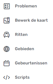
The left side of the editor screen contains the left hand side menu. When you click this it expands and you can choose from a series of aspects:
![]() Issues: for working with User customization requests (UR), Post customization requests (PUR) and Map Problems (MP) and Map Suggestions (MS).
Issues: for working with User customization requests (UR), Post customization requests (PUR) and Map Problems (MP) and Map Suggestions (MS).
![]() Edit the map: to edit the data of the map component that is currently selected.
Edit the map: to edit the data of the map component that is currently selected.
![]() Rides: for an overview of your past rides with Waze.
Rides: for an overview of your past rides with Waze.
![]() Areas: for an overview of your Areas where you may edit the map.
Areas: for an overview of your Areas where you may edit the map.
![]() Events: for working with Major Traffic Events.
Events: for working with Major Traffic Events.
![]() Scripts: with the settings of the active added Scripts.
Scripts: with the settings of the active added Scripts.
and at the very bottom left:
![]() Settings: Some settings can be adjusted here.
Settings: Some settings can be adjusted here.
The menu is displayed at the top of the screen with a number of icons next to the search field.
![]() Clicking on this icon will display options for adding a map comment.
Clicking on this icon will display options for adding a map comment.
![]() A Place can be added via this option.
A Place can be added via this option.
![]() A road can be added via this option.
A road can be added via this option.
![]() This option provides support for working with areas.
This option provides support for working with areas.
![]() This option allows Hazards such as speed cameras, railway crossings, toll gates to be maintained.
This option allows Hazards such as speed cameras, railway crossings, toll gates to be maintained.
Share location Share location, with this button you can request a permalink and the coordinates of the current location.
![]() Measure the distance between two points.
Measure the distance between two points.
![]() Request Streetview at the current location.
Request Streetview at the current location.
Show my location Go to my current location.
Bottom line
By clicking on ![]() you can make yourself visible to other editors who have the WME map open in the same area. With visible editors you can chat.
you can make yourself visible to other editors who have the WME map open in the same area. With visible editors you can chat.
Clicking on Keyboard Shortcuts calls up a panel with available key combinations with which you can perform editing actions and change settings.
Clicking on Get Help will call up the main page of the community hub site. In addition to the wiki, an extra site with an explanation about editing the Waze map.
The label Map Editors Forum takes you to the Forum page of the Benelux.
| 100 m | Indicates the size indication at the current zoom level.
The numbers at the bottom right, such as 52.98689, 6.56409, indicate the coordinates of the current location.
Clicking on Live Map calls up the [Live Map] at the current location.
Further reading
- The global page, already mentioned above, Map Editor Interface and Controls contains a complete description of the Waze Map Editor.
- Additional editing tips page.
- Visit the global page on Map Editing Tips and Hints
- Waze Map Editor Forum page with discussions, suggestions and version info.

