Ramp/en
Ramp
Ramp
Road type for entrance and exit ramps.
Attributes:
| Street | City | Lock |
|---|---|---|
When to apply
- Entrance and exit roads of Freeway and highways.
- Entrance and exit roads of bridges and tunnels.
- When a "Exit R/L" is more clear than a "Keep R/L"
Entrance roads
Entrance roads indicate a certain direction. Streetname: only the first number of the destination road. Destination city names that are mentioned on the road signs, are added to the street name, separated by a '/'.
Examples:
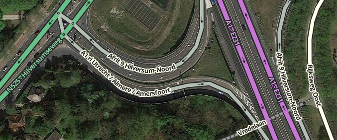
- A1 ri Utrecht / Almere / Amersfoort
- N201 ri Hoofddorp / Den Haag
- S116 ri Ring A10 / Noord
Exit roads

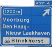
Official name and number of the exit: If the Exit has been numbered, the number must be added to the street name like Afrit 9. Destination city names that are mentioned on the road signs - standard the 1200m signs - are added to the street name, separated by a '/'. By preference, only the first two directions indicated are used. Skip black-on-white and white-on-brown names if a regular white-on-blue name is available.
See also the Road shield page.
Urban area: (When road signs deviate from the official name: ri followed by the directions, as indicated on the road signs.)
- S118 Noord 100-399
- S115 ri Boven 't IJ / Buikslotermeer
- ri Sint Franciscus
Outside the city: (Road numbers aren't added to the name of the exit.)
- Afrit 9 Hilversum-Noord
- Afrit Kaatsheuvel
Exit angle

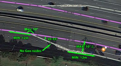
The picture on the right shows the most ideal way to draw an exit. Make the angle of exits with the main road at least 18° so that FS 'sees' that it is an exit and maximum 25° degrees to get a smooth animation of the car symbol.
Connecting roads crossing motorways
How to deal with connecting roads between different (Freeways)?

Connecting roads between different Freeways, often single-lane, sign BB01 (see next to it), where the speed driven usually has to be reduced, are designed as Ramp. This will mainly apply to crossing Freeways / cloverleafs. We use Ramps in principle for on- and off-ramps where the instruction "exit right" is desired. The app zooms in when you approach a Ramp on your route.

Multi-lane connecting roads with sign BB03 (see next to it) are designed as Freeway. This will mainly apply where a motorway branches off from another motorway while the speed can be maintained. The Wazer receives commands such as "keep left / right".
Note: The start of a parallel lane must be marked as a Ramp on the map in connection with DPM.

