This page lists the symbols, colors, and other items displayed in the Waze Map Editor and provides a reference for further explanation.
In addition to the map as it is displayed by default in the Waze Map Editor, scripts can customize the map and add color and other symbols. This page only includes the standard map components.
Roads
Enable the map layerRoad to show and maintain. Multiple selections possible.
A place of the logies category with subcategories such as hotel, camping, cottage, bed and breakfast
A place of the buiten category with subcategories such as park, playground
A place of the natuur category with subcategories such as river, canal, sea, lake, forest, trees
A parking lot is always an area place. Enable the map layer to display and maintain it.
A place of the woning category is always a point place and has a subcategory eigen woning. Enable the map layer to show and maintain it.
When working with a point place the place is shown enlarged white blue outlined. Here a selected place of the garage category.
A selected area place is shown as a turquoise polygon with the black move handle.
Area places are shown as a pink polygon.
Map Comment
A map comment. Comments can be placed on the map as a point comment and as an area comment. Both are white. For this view, enable the map layerMap Comments.
Closures
To display and maintain Closures, the map layerClosures must be activated:
 see Freeway
 see Major Highway
 see Minor Highway
 see Ramp
 see Primary Street
 see Street
 see Narrow street
 see Off-road
 see Parking Lot Road
 see Private road; destination traffic
 see Ferry
 see Railroad
 see Runway/Taxiway
 see Walking trail path with destinations
 see Pedestrian Boardwalk, path without destinations
 see Stairs
 The red outer lines indicate that the street name is missing
 The brown broken line indicates that the road is unpaved
 The arrows indicate a 1-way traffic road in the direction indicated by the arrows
 The red crosses indicate that the direction of travel is unknown
 The Yellow breaks indicate a restriction. Here on a regular Street
 The blue line indicates a toll. Here on a Freeway
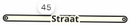 The number
  next to the road is a house number
 A new segment
 An existing selected segment
 A segment to be deleted
 A Junction Box
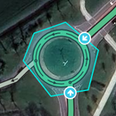 A selected Junction Box with the inputs


 and
and  see Junction Arrows
 see Soft turn and on the USA wiki
 and
and  see U-turn
 en
en  see Speed cameras
 see Railroad crossing
 see Tol
 A place of the garage category with subcategories such as Gas Station and Laadstation
 A place of the vervoer category with subcategories such as Bridges, Tunnel and Verzorgingsplaats
 A place of the professional en openbaar category
 A place of the winkels en diensten category
 A place of the eten en drinken category
 A place of the cultuur en drinken category
 A place of the overige category with subcategories Bouwplaats to use for new residential areas
 A place of the logies category with subcategories such as hotel, camping, cottage, bed and breakfast
 A place of the buiten category with subcategories such as park, playground
 A place of the natuur category with subcategories such as river, canal, sea, lake, forest, trees
 A place of the woning category is always a point place and has a subcategory eigen woning. Enable the map layer to show and maintain it.
 When working with a point place the place is shown enlarged white blue outlined. Here a selected place of the garage category.
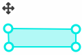 A selected area place is shown as a turquoise polygon with the black move handle.
 Area places are shown as a pink polygon.
 A map comment. Comments can be placed on the map as a point comment and as an area comment. Both are white. For this view, enable the map layer Map Comments.
 A closure that is not yet active, see Closures
 Active closure, see Closures
 A closure that is no longer active, see Closures


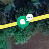
 New UR's update requests open for zero to five days are yellow; one without and one with a response
 Orange UR's are open for between 6 and 14 days.
 Red URs have been open for 15 days or longer.
 Closed URs. Gray indicates problem not identified, green problem solved
 This symbol represents multiple URs. Zoom in for the individual URs.
 PUR, place update request. The number indicates that there are three Place update requests at this location.
 A Flagged place update request
 A problem on the map, see Map problems
 A suggestion for a map change from an editor with too low a level to make the change himself.
 The segment suggestion relates to the purple segment.